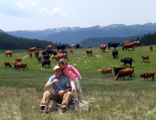
 We made our first foray into the Southeastern San Juan range last weekend. This area is much less traveled than the "normal" San Juans, i.e. Silverton, Lake City, Durango, Ouray, Telluride etc. It does not have the jaw dropping rugged mountain views but it does have jaw dropping pastoral mountain views and remoteness.
Starting at Antonito, we drove west thru the beautiful Conejos River Valley. Lot's of crags on the North side of the road. After Horca, we headed generally NE toward Platoro Reservoir. Along the Lake Fork of the Conejos, I had trouble staying on the road while driving. I wasn't even drinking. There was SO MUCH ROCK of different types. Even if only a fraction of it were of climbable quality, it could be a destination area. I didn't see many cracks which means it would have to be developed (bolted). Unfortunately climbers in this region are rare. More on this another time since I didn't have time to stop and hike up.
We made a nice camp at Lily Pond Lake (11,900') near Stunner Pass. While getting firewood, I let Julia find her way back to camp. While great practice, I'm very glad it was practice. :-)
We drove up to Kerr Lake the next day. We hiked around the lake while teasing the fish. No go there. We did attract two DOW officers though. There was another group close by. The officers split up and one came towards each group. I couldn't see a uniform until the last 50 feet when he opened his vest. I did NOT like this approach and was worried about our family's safety until this point. I was getting into defense postion until at last I saw his uniform. He was a nice guy, of course, after we talked. Bad way to approach though. I could see being a DOW officer ... getting out in the forest on a daily basis.
We headed towards the Stunner mining camp, past the Crater Lake trailhead and then to the infamous Summitville - where the environment mining disaster happened. The entire area is worth much more exploring. We'll be back. This was only the first foray.
I mapped the general route here.
All the pics are here.
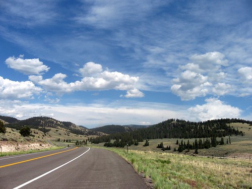 We drove 114 between Saguache and Gunnison (map). Beautiful country. Reminds me of Wyoming's South Pass region, south of Lander. By the time we reached North Pass (topo), I realized there was much to explore in this little traveled region. Yeah, 114 was paved but we had passed only a few vehicles since Saguache. Only need more time ...
Gunnison was bustling with activity. At a population of 5000, it was 10 times as populated as Saguache and Saguache has 8 times as many people as Crestone. It was fun. We stopped in a sports store to pick up fishing licenses and then to the climbing/ bike shop for a guide to Taylor Canyon. I hadn't climbed in Taylor Canyon for 27 years. Mia hadn't ever. I DID remember that Taylor was a funky place ..
We found a great place to camp at the North Bank campground. The site was next to the Taylor River and next to another site with 2 kids. Perfect for everyone. The in place for the kids to play turned out to be the bed in the truck. That made them easy to keep track of. Also we could walk to the crags.
The old guide we picked up left much to the imagination (c'mon Fred, where's that new Sharp End guide?). Climbing with Julia makes it a bit more of a challenge to pick out routes that we can get down from - ie. one pitch routes. We started w/ Tony's Tango (Mia leading), a really nice 5.6. I led Left Hand, a 5.8+. Both were exellent routes. I remembed why Taylor's Canyon is funky though .. realistic ratings can be obtained by adding a full grade to the grade in High Country Stone guide. Julia climbed and we toproped a few more routes - then it was HOT !!
So we headed up to Crested Butte for ice cream .. and did a driveby of the cliffs along Cement Creek when Julia fell asleep on the way. CB is fun. We had Pizza and beer too - after the ice cream. A scenic drive via Lake Irwin and Ohio Pass (pic) took us back to camp.
Sunday was to be hot also. Mia was still cooked so we drove to a small climbing area near Powderhorn hoping to find some shade. We did one climb in the sun and Mia called it quits. Even at 9000 feet, it was still too hot. The rock at Powderhorn looked like crap but was actually pretty decent. I'd come back if in the area.
Driving back via Powderhorn (map), Cebolla Creek, Cochetopa Pass was worth the detour. We also saw lot's of potential new crags ... just need more time.