31 July 2006

Monitor Rock Climbing & Fishing

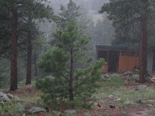
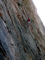
Last weekend, we escaped the heat wave again. We climbed some new, for us, routes on the West face of Monitor Rock. Monitor Rock is West of Twin Lakes. Beautiful weather up there. The picture to the left is Chris Beh climbing a nice bolted 5.10. This climb is not in the guide but is 3 or 4, bolted lines right of Squid Kid and behind the huge tree.

Later, I got attached to a steep slab that looked improbable. We couldn't find the climb in the guide. The first 4 bolts went fine. Really fun climbing. Then came the goods. Really tough slab climbing with funky side pulls and underclings. A couple falls and I clipped the next bolt. More chess moves led the the next bolt. Yeah, I fell here too. After that it was improbable for me. So I let Chris check it out. He also had fun where I did and reached the improbable moves. After confirming it was improbable, we did some kid sitting and let Mia and Gali have at a nice 5.10, Grave Line. It turns out the climb Chris & I tried is Matchless and 5.12a. I'll have to come back when I'm stronger, lighter & taller! Right ...

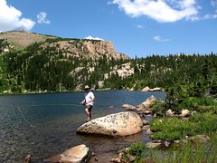
Our families split up the next day and we went fishing at Windsor Lake. This lake is West of Turquoise Lake and 800 ft elevation gain over approx. 1.6 miles. Julia did great on the hike. Mia kept her going with a story about German immigrants arriving in the U.S. I don't know where Mia gets this stuff!

Worms didn't do much for Mia and Julia but I finally had time to try my new fly fishing rig! I actually caught a few fish. Largest was about 9". They jumped out of the water and fought well. I think they were some kind of cutthroat or cutthroat/rainbow hybrid. I was pretty psyched to actually catch something. It was time to hike back to the truck and face the front range bound traffic ...

More pics here.

28 July 2006

Steve Mestdagh - the stuntman

Yesterday, I had my 15 seconds of fame. I was a stuntman double for Sfc. Mike McNaughton. Mike lost his leg, due to a landmine, in Afghanistan. (Check the link. Yeah, we actually look sort of similar after I got my hair cut to military length.)

A friend of a friend turned me on to a talent agency that was looking for .. get this .. a right legged amputee who is an experienced climber. Due to lack of applicants, I got the job. :-)

The film was a patriotic music video for the Lonestar Bluegrass band. It was to be about 4 minutes long. There must have been 50 people directing, filming, lighting and assisting the 2 actors and the stuntman, me. It must have cost a fortune. The film crew was from Los Angeles.

The video has two stories. Mike and his athletic comeback and a woman, played by Brit Roberts, who put herself thru school working at IHOP. Mike was filmed running, which he did fine by himself, and climbing. I climbed with Brit on one climb - the classic, first pitch of the Bastille Crack. I also rigged a toprope on a climb that goes up the side of the Whale's Tail. Not many good anchors to be had on the Whale's Tail but I found solid placements. Don't want anyone dieing on film!

After I setup the toprope, it started raining. Christie, the beautiful and sassy producer, asked me if I could still get the ropes up there if it's wet. I said for an extra $500 dollars, no problem. She laughed and said she liked my attitude. I think I could go far in show biz. :-)

The rain stopped and we did the top rope session. For this, the camera was mounted on rails, like a train, and slid back & forth with the film guy looking down into the camera. After the top rope session and ... many up & downs for Mike & Brit, it was time for the Bastille Crack. A PA (production assistant) said he'd carry my pack over. I couldn't dissuade him and hoped to hell no one I knew saw me. I'd never live it down! After awhile I almost got used to the coddling. I didn't mind too much when Brit helped me put my harness on.

Brit didn't lead so it was my show. The camera was mounted on a 45 ft crane and followed me up the climb. I could feel it a few feet off my back at one point. The Bastille Crack is a riot to climb in ordinary conditions. I must be a ham because it was even more fun while being filmed. I whizzed up it in about 5 minutes.

Then Mike was filmed running across a finish line. Click on picture for the enlarged view. After this we did one final shoot in Eldorado. Brit & Mike pulling over the "summit of the mountain". The "summit" was actually a big boulder up on the Fowler trail. I must have looked a little confused at the summit shot because the director told me: Yeah, we're faking it ..

Brit was off with a smaller crew for one final shoot at a diner. Mike went to the hotel with his wife. I drove home. Sort of a let down after such a fun day. Back to the normalcy of life. Dang!

Click here for the pics.
Sorry no shots of me. I was busy or waiting to be busy.

25 July 2006

I'll be a stunt man!

I'm almost afraid to write this up until it happens. A friend of a friend turned me on to a talent agency that's looking for a right legged amputee climber. That's me! How many of us are there? Not many. So I got the job!

In a nutshell, there's a bluegrass band involved and I'll be the stunt man for an army guy that lost his leg in Afghanistan - landmine. I'm not sure who is supporting who. Sounds like sort of a MTV / DVD skit. They sent me the "treatment". The treatment is a rough sketch of what will happen. I don't want to blow my luck so I won't say more.

I sent them pics & my clothe sizes. They asked if my hair length is still the same as in the pictures. I said: yeah, it's normal length. They said get it cut to NORMAL length! I said ok. (Hey, they're paying me to climb.)

I was going to let Julia have fun and cut my hair. Then I'd finish it up w/ a #2 beard trimmer. Mia said: No way!

I got it cut today. When the barber was finishing it up, I asked (without my glasses on): Is this going to make me look more mature? She said: Most definitely.

Dang!
When Mia saw it, she said: Wow! It turns out Wow means bad :-)
A picture will be forthcoming.

21 July 2006

Climbing at Lime Park

Last weekend, the temps were too high to stay home so we headed high. We headed up to Lime Park Friday evening. We drove in from the Eagle, North, side. It's a looonng way in on bumpy dirt roads. We found a nice camp next to Lime Creek and settled in for the night. I wish I had pictures but I forgot the camera. Lime Park is a large meadow surrounded by aspen and spruce. It doesn't get much better. Only the next day did we find out about the nasty biting flies ...

Next day, we climbed on the shady, West, side in the morning. Even at 9200 ft, it was shaping up to be a warm day. Without a guide, we had to guestimate the routes from below. We climbed a nice 5.9, two ok 5.10s w/ gravelly topouts, and 2 more excellent 5.10s. This limestone was not like Shelf Road. It reminded Mia & I of the limestone around Berchtesgaden, Germany - Mia's hometown. Lot's of slopers and sidepulls. After lunch, we climbed on a NE facing wall on the other side of the valley. I pulled through an excellent 5.11a. We also did a mediocre 5.10 to the left of it. Seven was enough for a day and Julia reminded us it was time for fishing.

A little pool looked like it might be full of fish ... but nothing. It was fun anyway. Next day was Julia's day. We went fishing at a better pool. We saw the fish rising but we coudn't fool them. Skunked again.

On the way home, we took the dirt road South to Thomasville, then East over Hagerman Pass. Beautiful aspen filled drive. We stopped in Leadville for ice cream!

17 July 2006

Map of the SW Colorado family trip

I checked out the path mapping of CommunityWalk this evening to map out our SW Colorado family trip. It does the job better than expected, as can be seen in the screen shot here. This is the best mapping site I've used, for my needs. I've tried most of the mapping sites, too.


Although the trip started and ended in Boulder, I started the trip path in Crestone and ended it in Glenwood Springs, to reduce the clutter. Click on the map to go the CommunityWalk site and explore further. (i.e. click on the markers.)

13 July 2006

SW Colorado family trip - part 3/3; best camp and water fight western style

We couldn't find a good camp down low so we headed high. Picayune Gulch to be exact. The 4x4 guide said easier than Engineer Pass, with an exposed shelf road start, so we headed up. MIa & I were not happy. Luckily Julia said - Papa can do it. Mia & I kept quiet and continued. It was steep and gravelly with a steep drop off, let's say a cliff, to the left. I would have rather been in 1st gear 4x4 Hi but I didn't want to let off the go pedal to shift so I stayed in 2nd. Man, was it steep .. and gravelly. Tires didn't spin though. Bump did fine, with my nervous guidance.

We found a great site at 12,075' according to my GPS. The picture above is from the next morning. Here's another picture from the morning .. and here's one showing the evening before with clouds moving in.

The next morning we headed up the road to a saddle and Julia climbed her second 13K peak. Again, we were amazed. We drove down Placer Gulch and stopped at the Silver Queen Stamp Mill.

Mia had enough of waterfalls, mines and bumpy driving. We headed for Silverton to be real tourists. A good meal and we headed to Ouray, as the streets flooded in Silverton. I mean the streets were streams.

We were to meet Christy at the mountain store at 6pm. We found her and a camp site .. at a secret location. It was 4th of July weekend and the pickings were slim. We climbed some nice but odd climbs the next day, at Pool Wall. I, and later Christy, got spanked on a 5.10d. No way 10d, sez I. The rain kicked in and we waited it out under an overhang. While we were waiting, we hear a roar. A flash flood comes out of a gully off to the side. Spectacular. Wish I had the camera for that one.


Then to a real western waterfight. Two firefighters against 2 other firefighters. There were even referees. It was packed in downtown Ouray and the crowd was rowdy. These guys must have been exhausted .. and hypothermic after an hour of this stuff.

We found some better climbs, at Pool Wall, the next day. I'd definitely recommend Empire of Dirt, 5.10d. Overhangs, slabs, pockets ... If you're short bring a stiff draw for this and others at Pool Wall. It started raining again. We checked the forecast. The rest of the week's forecast was worse. We drove home. A stop in Paonia for fresh cherries finished the trip nicely!

Check here for the trip picture album.

SW Colorado family trip - part 2 & Julia's 1st 13K summit

Engineer Pass, between Lake City & Animas Forks - N. of Silverton, was pretty mellow on the east side. I wasn't seeing any full size trucks coming from the opposite direction though. This made me a bit nervous. The scenery was fantastic though. Mia rolled her eyes at every water fall I stopped at. There were many!

We parked at the top of the pass, enjoyed the view and headed up North of the pass to tag the nearest summit. Julia hiked up all the way. She liked the scrambing at the top. It was her first 13,000 ft peak. We was really impressed! The 2nd picture is Julia & I at the summit.

The Animas Forks, West side, of the pass was more interesting. A real shelf road with less places to pass and some steep switchbacks. Not really a challenge for Bump, the rig, but I didn't want any real scares either. That would come later, unexpectedly.

Animas Forks is definitely worth a visit. (Really, you drive right by it, why not?) There's been a lot of restoration work ... and much more to do. Here's a heck of an artistic picture I took, looking South, from inside a cabin.

Lessee, maybe that's enough for part 2.

09 July 2006

Incredible fire picture in Bitterroot National Forest


I found this on one of my RSS feeds. Incredible picture of a forest fire! Click on it for full size image and description.

07 July 2006

SW Colorado family trip - part 1

From the San Luis Valley, we drove to the town of Del Norte and the Rio Grande River. There's a great museum/ vistor center here. A half hour wasn't time to do it justice and we will be back. Del Norte seems to be where the valley starts changing to a mountain feel. No more crop circles here.

We followed the Rio Grande upstream through South Fork and stopped at Creede. Beautiful country but really getting built up. It was raining in Creede. We did a mine tour at the mouth of the canyon. The tour was developed around the change in mining technology. Well worth it. Lot's of mines to explore North of town but with the rain, we decided to continue upstream and find a camp.

You know you're in the Colorado Southwest when you see sheep. These guys were being herded alongside the road.

We found a nice camp at Bristol View campground. Excellent view and only one other camp site occupied. (Further down the road there were many options for primitive sites but we didn't see that until the next day.) We tried some fishing before dinner. It looked promising but nada.

We stopped at the impressive N. Fork of Clear Creek Falls the next day as a drizzle had already set in.

The rain increased as we headed higher. It was pouring as we crossed Slumgullion Pass (11,361'). The truck outside temp gauge displayed 39F at the pass.

We pulled into a crazy Lake City. This is one of the staging points for the scenic Alpine Loop. Read more about the alpine loop here, here & here. The 4x4/ ATV crowd were everywhere in their tricked out rigs. We wanted out of there and fast. The weather had moderated ... we hoped anyway as we wanted to do the North half of the loop - Engineer Pass. More in part 2!